
Cyclone Formation Probability
Images showing probability that weather disturbances across the globe may developed into a cyclone.
0-24 Hours
24-48 Hours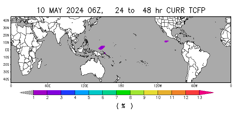
Courtesyof RAMMB-CIRA-NOAA
World Weather Satellites Feed
Latest weather satellite feed of the entire world.
Infrared

Image courtesy of Plymouth Weather Center
Infrared 2

Image courtesy of Accuweather
Composite Infrared

Image courtesy of SSEC: UW Madison
World Marine Weather
Different weather maps showing forecast marine weather in the world.
Wave Heights & Direction

Sea Surface Temperatures

Surface Analysis

Source: OceanWeather© .com
Probability of Weather Hazards in the World in 2 Weeks
1-2 Weeks Advanced Typhoon Probability & Weather Forecast Model
Probability that an area in the world may experience Typhoon/Cyclone/Hurricane formation, above & below average rainfall & above & below normal temperatures.
WORLDWIDE:

PACIFIC OCEAN FOCUS:
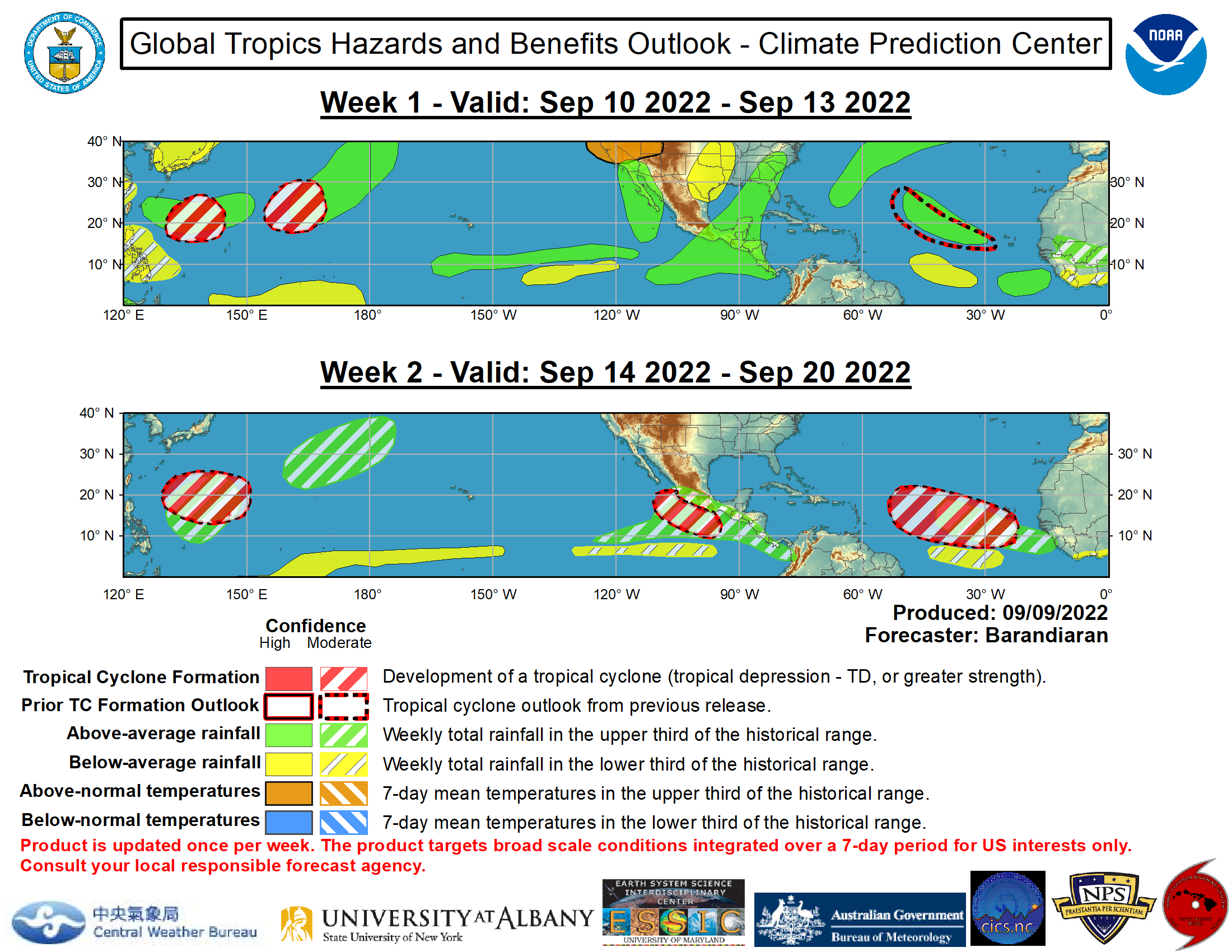
Source: NOAA – Climate Prediction Center
Worlwide Heavy Rain/Snow Warning
Worlwide Heavy Rain/Snow Warning

• reported at the latest synoptic hour;
+ reported 6 hours earlier;
■ reported 12 hours earlier;
▼ reported 18 hours earlier;
▲ reported 24 hours earlier.
Worldwide Thunderstorm Warning
Worldwide Thunderstorm Warning

• reported at the latest synoptic hour;
+ reported 6 hours earlier;
■ reported 12 hours earlier;
▼ reported 18 hours earlier;
▲ reported 24 hours earlier.
Source: World Meteorological Organization
Worldwide Gale Warning
Worldwide Gale Warning

Definition of Gale : Wind speed greater than or
equal to 34 knots or 18 m/s
• reported at the latest synoptic hour;
+ reported 6 hours earlier;
■ reported 12 hours earlier;
▼ reported 18 hours earlier;
▲ reported 24 hours earlier.
The gale reports are based on the weather
observations extracted from SYNOP reports
from land stations and ships of WMO
members. Only limited data quality checks are
applied, care must be taken in interpreting or
using the gale data.
Please note that the altitude of land stations
would affect the observed wind speed. The
altitude of the station is the reference level to
which barometeric pressure reports at the
station refer.
Source: World Meteorological Organization
Worldwide Lightning Activity
Current lightning activities worldwide.

Skyblue Dots – Most Recent (about 10 mins ago)
Yellow & Green Dots – Recently (10-30 mins ago)
Red Dots – Oldest (30-40 mins ago)
Red Dots with White around not included
Daily Average Density of Lightnings

Courtesy of University of Washington | http://www.wwlln.net
Current World Weather
Current temperature & conditions of cities around the world.
Courtesy of YouWeather
HOURLY ACCUMULATED RAINFALL (Worldwide)
Worldwide including Philippines accumulated rainfall, measured in millimeters per hour. Color indicates amount of rainfall that an area is experiencing. See scale below.
Mga kasalukuyang pag-ulan sa mundo kasama ang Pilipinas. Ang dami ng ulan ay sinusukat sa pamamagitan ng millimeters bawat oras. Ang mga kulay ay nagpapakita kung gaano kadami ito. Tingnan ang scale sa baba.


Source: Japan Aerospace
Exploration Agency (JAXA).
AFFILIATES


COMMENTS